Villuercas-Ibores-Jara Geopark
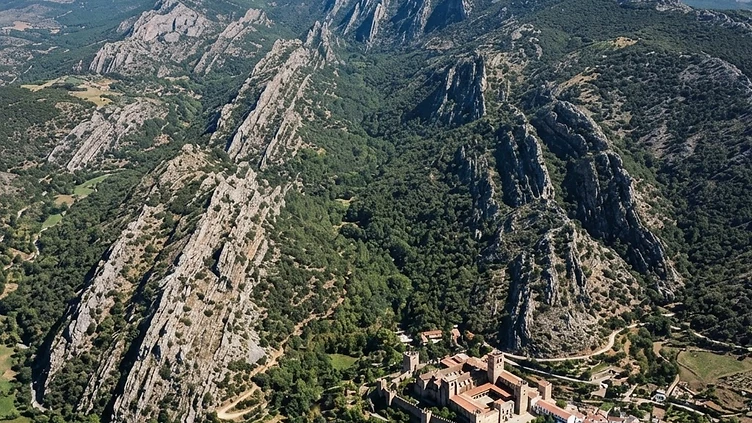
A half day of driving and viewpoints, or two days of walking. Spring is the season.
The clearest folded mountain structure in Spain, and it is almost empty of visitors.
At a Glance
Villuercas-Ibores-Jara became a UNESCO Global Geopark in 2011 for the clarity of its geology: Cambrian and Ordovician rocks folded into long, parallel ridges that run northeast to southwest, with hard quartzite crests, slate valleys and karst underneath. It is landscape as explanation — the Apalachense relief, one of the best displays of it in Europe, visible from any road in the area. There are signposted viewpoints, a cave system, and walking routes between villages. Bring the geopark leaflet and a car, and drive the crest roads slowly.
How it got here
These mountains formed a strategic boundary for the kingdoms of León and Castile. The Reconquista pushed the frontier through the river valleys, leading to the establishment of the Order of Alcántara. During the Middle Ages, the village of Guadalupe became a site of pilgrimage after a shepherd reportedly discovered a hidden statue of the Virgin Mary. King Alfonso XI built a sanctuary there, which the Catholic Monarchs later visited to fund the voyages of Christopher Columbus. This religious center dominated the economic and political life of the surrounding peaks for centuries, grounding the region in the ecclesiastical history of Castile and Extremadura.
Where it sits
Deep valleys separate the quartzite ridges that define the horizon. The landscape turns harsh and quiet once the main roads fade, leaving narrow passes between oak forests and slate slopes. Springs emerge from the rock, sustaining small villages where silence persists through the long summer afternoons. Autumn mists cling to the higher elevations, while winters bring frosts that empty the trails. This is country for the patient driver who navigates the turns between the mountains. It feels empty because the population retreated to the larger towns, leaving the scrubland to the goats and the hawks.
What to eat and drink
The cuisine relies on the produce of the dehesa, the open oak woodland. Jamón ibérico de bellota from pigs fed on acorns provides the primary flavor of the table. Torta del Casar, a raw sheep milk cheese with a soft, bitter center, arrives at the end of meals. Stews containing wild partridge or venison cooked with local olive oil and garlic provide heavy sustenance during the winter months. A glass of Ribera del Guadiana wine accompanies the plate, usually a robust red made from Tempranillo grapes grown on the lower, sun-drenched plains of the province.
Extremadura: the whole region
The emptiest region in Spain, and the one where the scale of the country is clearest: dehesa plains running to the horizon in every direction, hilltop towns built from the stone under them, and the best Roman remains in the country at…
Minimum 4 days · better 7-8 days · deep 12 days
In Extremadura


In Extremadura




Logistics are verified only. We don't publish schedules we haven't confirmed.
Ready to build Villuercas-Ibores-Jara Geopark into a trip?
You've found a place worth going. When you're ready to turn discovery into an itinerary, Travel Itinerary Co picks up where the Field Guide leaves off — with your saved places already in hand.
Build this into a tripContinues on Travel Itinerary Co
Spain Field Guide may earn a commission when you book through selected links. Recommendations are editorial and independent of commission.