Villuercas, Ibores and Jara
Two days: one for Guadalupe and the monastery, one for the geopark roads. Best in March and April for the flowers.
Folded mountains you can read like a diagram, and one of Spain's great monasteries, with no crowds.
Guadalupe Monastery · Villuercas-Ibores-Jara Geopark · Cañamero
At a Glance
- — You want dramatic peaks — these are long ridges, not summits.
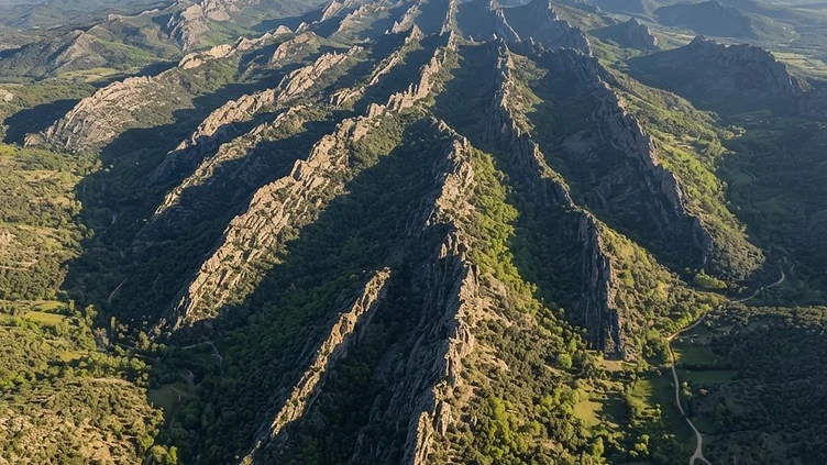
A range of long, parallel ridges in eastern Cáceres, where the geology is the attraction: Cambrian and Ordovician rock folded into sharp crests and valleys, recognised by UNESCO as a Global Geopark. Guadalupe sits at the eastern edge, a small town built entirely around a royal monastery that was for centuries the most important shrine in Spain. Cañamero, Logrosán and a scatter of hamlets sit between the ridges, living off olives, cork and sheep. The driving is quiet and the spring wildflowers on the slate are the best-kept spectacle in Extremadura, two hours from Madrid and almost unknown to foreign visitors.
How it got here
These parallel ridges acted as a frontier zone between the kingdoms of Castile and León during the medieval period. The Royal Monastery of Santa María de Guadalupe drew kings and explorers across these mountains for centuries because of a legend concerning a hidden statue of the Virgin. Pilgrims followed the royal roads through the crests and valleys, leaving an architectural imprint that still centers the town of Guadalupe. The isolation caused by the rugged terrain preserved these stone structures, while the decline of the traditional wool trade shifted the local economy toward small scale agriculture and forestry, leaving a landscape defined by monastic power.
Where it sits
The terrain consists of long, folded quartzite and slate ridges that run northwest to southeast. Spring turns the slopes into a carpet of rockrose and lavender while the heat of summer dries the valleys into shades of brown. Narrow roads wind through the passes between villages like Cañamero and Logrosán, connecting the eastern edge of Extremadura toward the central plains. Traffic stays light even during peak travel months because the winding, slow geography demands patience. Winters bring frost to the higher ridges and quiet descends upon the stone hamlets when the mist gathers in the folds of the earth.
What to eat and drink
Cuisine relies on the products of the dehesa and the local mountain slopes. Caldereta de cordero, a thick stew of lamb with garlic, peppers, and paprika, anchors the diet of the shepherd tradition. Torta del Casar, a raw sheep milk cheese with a soft, creamy interior and a thick, yellowish rind, comes from the surrounding pastures. The region produces honey of exceptional quality derived from the heather and chestnut flowers of the high ridges. Wine production centers on the local pitarra style, traditionally fermented in large clay vessels and kept for home consumption in the mountain villages.
Extremadura: the whole region
The emptiest region in Spain, and the one where the scale of the country is clearest: dehesa plains running to the horizon in every direction, hilltop towns built from the stone under them, and the best Roman remains in the country at…
Minimum 4 days · better 7-8 days · deep 12 days
In and around Villuercas, Ibores and Jara





In Extremadura


In Extremadura




Logistics are verified only. We don't publish schedules we haven't confirmed.
Appears In
Ready to build Villuercas, Ibores and Jara into a trip?
You've found a place worth going. When you're ready to turn discovery into an itinerary, Travel Itinerary Co picks up where the Field Guide leaves off — with your saved places already in hand.
Build this into a tripContinues on Travel Itinerary Co
Spain Field Guide may earn a commission when you book through selected links. Recommendations are editorial and independent of commission.