Cañamero
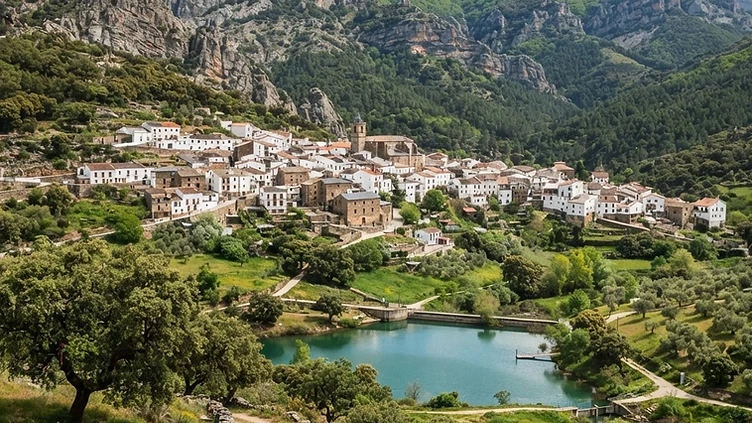
Stay here for the geology; Guadalupe for the monastery. Not both.
The base for the geopark's ridges and the best walking access to them.
At a Glance
Cañamero sits at the foot of the Villuercas massif, where the olive groves stop and the ridges begin. It is a plain, working village — a plaza, a church, a couple of bars — but it is the most practical base for the geopark roads, and the interpretive centre for the geology is here. From the village, tracks climb quickly into the folded country, where the rock bands run in long parallel lines and the spring flowers are extraordinary. Practical rather than pretty, and all the better for it.
How it got here
Archaeological findings of rock paintings in the nearby caves point to human presence since the Paleolithic period. During the Reconquista, the territory fell under the jurisdiction of the Order of Alcántara after the Christian advance moved south toward the Guadiana river. The village grew as a transit point within the kingdom of Castile, serving the livestock trails used by the Mesta. Long defined by its proximity to the royal road connecting Toledo and Seville, the village maintained its administrative status within the province of Cáceres. The current morphology follows the expansion of agrarian activities throughout the eighteenth century when local farmers focused on cereal cultivation and viticulture.
Where it sits
The village sits at the base of the Villuercas mountain range where the terrain shifts from the agricultural plains of the Tajo river valley to the folded quartzite ridges of the UNESCO Global Geopark. Quartzite crests dominate the horizon, creating a landscape of deep valleys and narrow mountain passes. Winters bring frost to these slopes while the summer sun heats the exposed rock. Roads through the village climb into the sierra, connecting to remote villages isolated by the complex geography. Traffic remains light outside of harvest seasons, as the landscape favors mountain grazing and ancient trails.
What to eat and drink
The local diet relies on the produce of the Extremaduran countryside. Caldillo de patatas, a thick stew of potatoes with chorizo and pimentón, sustains laborers during the colder months. Pork products appear in every pantry, particularly the chorizo and morcilla spiced with the local paprika from the nearby La Vera valley. Migas, pan-based breadcrumbs fried with garlic, olive oil, and bits of pork, serve as the standard plate. The village produces its own wine, typically young and robust, which accompanies the regional goat cheeses and cured ham produced from acorn-fed pigs roaming the oak forests of the province.
Extremadura: the whole region
The emptiest region in Spain, and the one where the scale of the country is clearest: dehesa plains running to the horizon in every direction, hilltop towns built from the stone under them, and the best Roman remains in the country at…
Minimum 4 days · better 7-8 days · deep 12 days
In Extremadura


In Extremadura





Other Quick Stop in Extremadura



Logistics are verified only. We don't publish schedules we haven't confirmed.
Experiences worth booking ahead
Spain Field Guide may earn a commission when you book through selected links. Recommendations are editorial and independent of commission.
Ready to build Cañamero into a trip?
You've found a place worth going. When you're ready to turn discovery into an itinerary, Travel Itinerary Co picks up where the Field Guide leaves off — with your saved places already in hand.
Build this into a tripContinues on Travel Itinerary Co
Spain Field Guide may earn a commission when you book through selected links. Recommendations are editorial and independent of commission.